A powerful offshore earthquake has struck southern Philippines, resulting in fatalities, significant structural damage, and tsunami alerts across multiple nations.
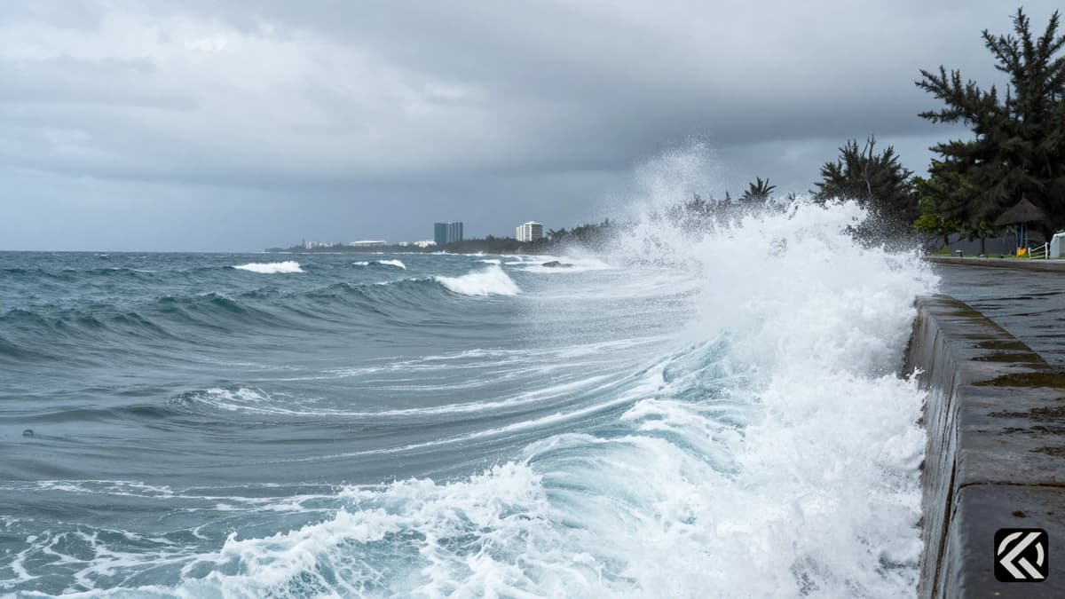
The Philippines was shaken early Monday, June 8, 2026, by a powerful offshore Magnitude 7.8 Earthquake that caused widespread destruction and loss of life in the southern regions of the archipelago. The seismic event, centered approximately 13 kilometers southwest of General Santos, triggered a tsunami that washed ashore on nearby coasts and resulted in at least four deaths and more than 200 injuries, according to official reports.
President Ferdinand Marcos Jr. reacted swiftly to the crisis, urging immediate evacuation of vulnerable coastal areas. The president stated that disaster-response agencies were on standby and emphasized the national government’s commitment to supporting the affected regions. The quake was felt not only in the Philippines but also in nearby Malaysia, with tsunami waves detected in Indonesia and Malaysia, leading to cross-border warnings and heightened alert levels in neighboring nations.
The primary impact zone was General Santos, a major commercial hub for tuna processing and other commerce in the southern Mindanao region, home to more than 700,000 people. Rod Sosmeña, the regional director of the Office of Civil Defence, reported that at least three people were killed and 130 others injured in the city. The quake caused several small buildings to partially collapse and left dangerous cracks in structures, including a key access bridge essential for the city’s connectivity.
Sosmeña described the terrifying moment the quake hit while he was being driven to work. He noted that his pickup truck suddenly jerked, initially making him believe he had a flat tire, before he realized the ground was violently shaking. Residents fled their homes and dashed into the streets in panic. Despite the severity of the shaking, there were no immediate reports of people trapped in the partially collapsed structures in General Santos at the time of reporting.
The disruption to infrastructure was extensive. Civil aviation officials confirmed that the international airport in General Santos was temporarily shut down, resulting in the cancellation of 17 domestic flights. This closure highlighted the significant logistical challenges facing the region as emergency responses were mobilized.
The Department of Health confirmed that another person died in the nearby Davao Oriental province due to the quake, bringing the total death toll to four. In a nearby southern region, Ednar Dayanghirang, director of the Office of Civil Defence, reported that more than 100 students sustained bruises or fainted from panic during morning flag-raising ceremonies at various grade and high schools.
Media outlets also reported damage to their infrastructure. DZRH radio station in Manila reported that a small commercial building housing its provincial branch partly collapsed. Staffers managed to reach the ground floor without injuries, though it remained unclear if others were trapped in the rubble of the four-story office building. Debris from the collapse fell onto tricycle taxis parked below, adding to the chaos on the streets.
Eyewitness accounts painted a picture of sudden terror. Mr. Sosmeña recounted the immediate chaos as people rushed out of houses. Ednar Dayanghirang, speaking from southern Davao, described the physical intensity of the quake, stating he could hardly stand or keep his balance while leaving his own house. These personal testimonies underscore the violent nature of the seismic activity that swept through the region.
The earthquake triggered significant water disturbances. Waves of 1 meter (3 feet) were monitored in the Philippine provinces of Sultan Kudarat and Sarangani by land-based tsunami watch stations. Smaller waves were observed in at least one other province. Teresito Bacolcol, director of the Philippine Institute of Volcanology and Seismology (PHIVOLCS), confirmed the detection of these waves and warned of potential damage based on video evidence of damaged buildings.
The Pacific Tsunami Warning Center (PTWC) issued broader warnings, stating that tsunami waves up to 3 meters (10 feet) were possible on some coasts of the Philippines. In neighboring countries, waves up to 1 meter (3 feet) were expected along some coasts of Indonesia and Malaysia. Malaysia’s Meteorological Department issued a specific Tsunami Warning for Sabah state on Borneo Island, which is geographically close to the southern Philippines. An 83-centimeter (2.7-feet) tsunami was measured by a gauge off Indonesia’s Sulawesi Island.
While smaller sea changes were possible in Japan, Papua New Guinea, and several island nations in the western Pacific, the threat level varied. An advisory for Guam was lifted about two hours after the initial quake, and the PTWC confirmed there was no threat to Hawaii. However, the immediate threat remained acute for the Philippines, Indonesia, and Malaysia.
The Magnitude 7.8 Earthquake was caused by movement in the Cotabato Trench at a depth of 10 km, according to PHIVOLCS. The U.S. Geological Survey (USGS) reported the depth of the original quake at 55 km (34 miles), noting that variations in measurements are common in the immediate aftermath of such significant seismic events. The USGS also recorded aftershocks up to 6.5 magnitude.
Mr. Bacolcol characterized the event as a major earthquake, stating that damage was expected and had already been observed in videos. "It’s a major earthquake, and we’re expecting damage," he told the Associated Press. The Philippines, located on the Pacific “Ring of Fire,” is one of the world’s most disaster-prone countries. It is frequently hit by earthquakes and volcanic eruptions due to its position on an arc of seismic faults around the ocean. The archipelago also endures an average of 20 typhoons and tropical storms each year, compounding the risks faced by its population.
As aftershocks continued to follow the 7:37 a.m. quake, the national government, led by President Marcos Jr., remained on high alert. The president’s declaration that "the national government is moving, and we will not leave Mindanao behind" signaled a coordinated effort to manage the ongoing crisis. Authorities in General Santos and surrounding areas continue to monitor structural integrity and tsunami levels as the region navigates the immediate aftermath of this devastating natural event.
The severe damage to infrastructure in General Santos, including collapsed buildings and a disabled airport, indicates a long recovery process. Given the region's location on the Ring of Fire and its exposure to frequent seismic activity, authorities must prioritize resilient infrastructure planning. The issuance of tsunami warnings for neighboring countries highlights the cross-border nature of these disasters, suggesting a need for enhanced regional cooperation in early warning systems and emergency response protocols to mitigate future casualties and economic losses in the volatile maritime sector.
Jun 8, 2026 06:22 UTC
Xi Jinping Lands in Pyongyang for Rare Kim Jong Un Meeting
Jun 8, 2026 04:15 UTC
Trump Urges Netanyahu to Halt Iran Strike for Peace
Jun 8, 2026 02:17 UTC
Magnitude 7.8 Quake Shakes Philippines, Urging Immediate Evacuations
Jun 8, 2026 00:51 UTC
Trump Claims Iran Nuclear Deal Imminent Despite Diplomatic Fractures
Jun 8, 2026 08:48 UTC
NEET-UG 2026 Paper Setters Placed Under Strict Isolation


